|
You have already found this cache! Master Index Nearest Caches  Naturpark Hohe Mark by mixxmaxx (1/3)
N51° 40.020 E7° 15.556 (WGS84) UTM 32U E 379617 N 5725437 Use waypoint: GC18FGD Size:  Not chosen Hidden on 8/01/2008 Not chosen Hidden on 8/01/2008
In Nordrhein-Westfalen, Germany Difficulty:  Terrain: Terrain: 
Add cache to watch list Log your visit Picture Gallery |
|
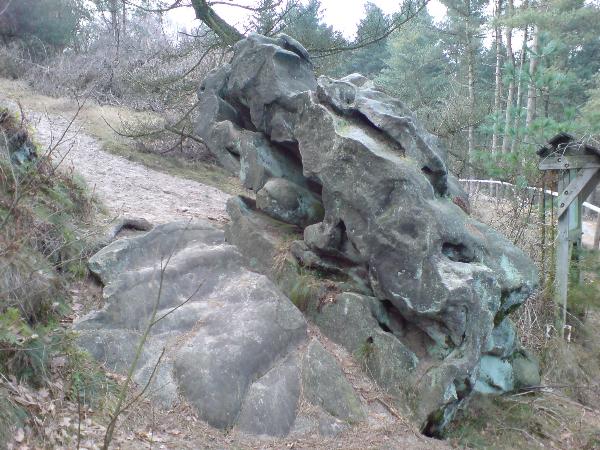
Naturpark Hohe Mark
Der Naturpark Hohe Mark dehnt sich auf einer Fläche von 1.040 km˛ aus und wird durch die Städte Rhede, Borken, Coesfeld, Dülmen, Lüdinghausen, Olfen, Datteln, Oer-Erkenschwick, Marl, Dorsten und Dinslaken begrenzt.
Der Naturpark zeichnet sich durch eine überraschende Vielfalt an Landschaftsformen aus. Während im Norden die Parklandschaft des Münsterlandes mit seiner vielfältigen Mischung aus Wiesen, Weiden, Äckern, Mooren und vereinzelten Waldstücken dominiert, findet sich im Süden ein zerfurchter Bereich, der von den Waldgebirgen Hohe Mark (das den Kern des Naturparks bildet), Die Haard und den Borkenbergen gebildet wird. Zwischen diesen Waldgebirgen erstrecken sich die völlig ebenen Flusslandschaften der Lippe und der Stever.
Der höchste Berg ist mit 156 m der Stimberg in der Haard.
Diagenetisch verfestigte mittelkörnige kreidezeitliche Quarzsande, auch „Halterner Sande“ genannt, bauen das gesamte Hügelland der Hohen Mark auf. Am Stimberg in der Haard finden sich Felsbänke aus Sandstein, der durch eine Mischung von Kieselsäure und farbigen Eisenverbindungen zementiert ist. Dadurch entsteht der sogenannte Schwartensandstein, der je nach Grad der Zementation eine große Härte erreichen kann. Dieser Sandstein findet sich auch als Baumaterial in der Gegend (z. B. an der Pfarrkirche von Recklinghausen).
Außerdem zeigt dieses Material auf der sonnenzugewandten Seite das Phänomen des Wüstenlackes, die man eigentlich nur in den großen Wüsten der Erde findet. Die Porösität des Schwartensandsteines nimmt Regenwasser sehr leicht auf. Bei Sonneneinstrahlung verdampft das Wasser wiederum und lässt die zuvor gelösten Eisenverbindungen auf der Oberfläche des Materiales als schwarze Schicht zurück.
(Quelle:Wikipedia)
Wenn Ihr diesen Cache loggen möchtet, macht Ihr
1) ein Foto von Euch mit dem Schwartensandstein bei N 51° 40.020 E 07° 15.556 .
2) ein Foto von Euch mit dem Schwartensandsteinen bei N 51° 39.914 E 07° 15.463 .
3) Schickt mir eine Mail und beantwortet folgende Frage:
Was für ein Gefahrenhinweis ist auf den Schildern neben den Schwartensandsteinen?

Nature Reserve High Mark
The nature reserve High Mark extends on a surface of 1,040 km ˛ and is limited by the cities of Rhede, Borken, Coesfeld,
Dülmen, Lüdinghausen, Olfen, Datteln, Oer-Erkenschwick, Marl, Dorsten and Dinslaken.
The nature reserve distinguishes itself by an astonishing variety in scenery forms. While in the north the park scenery of the
cathedral land with his varied mixture of meadows, pastures, moors and isolated forest pieces dominates, is found in the south
a furrowed area which is formed by the High Mark (which forms the core of the nature reserve) the Haard and the Borkenberge.
Between these areas the absolutely level river sceneries of the Lippe and the Stever the highest mountain apply the Stimberg
with 156 m in the Haard.
Slide-genetically hardened chalk-temporal quartz sand, also "Halterner Sande " called, builds up the whole hill country of the
High Marks. In the mountain Stimberg in the Haard are found rock benches from the sandstone which is cemented by a mixture
of silicic acid and coloured iron compounds. The so called Schwartensandstein which can reach a big hardness according to
degree of the cementation originates from it. This sandstone is also found as a building material in the area (e.g., in the parish
church of Recklinghausen). In addition, this material on the solar-turned side shows the phenomenon of the wild varnish which
one finds, actually, only in the big deserts of the earth. The skin of this sandstone takes up rainwater very easily. With solar irradiation the water evaporates again and leaves behind the before relaxed iron compounds on the surface of the material as a black layer.
If you want to log this cache
1) make a foto of yourself and the Schwartensandstein at N 51° 40.020 E 07° 15.556 .
2) make a foto of yourself and the Schwartensandstein at N 51° 39.914 E 07° 15.463 .
3) Sending to me a mail and answer the following question:
What danger tip is on the signs beside the Schwartensandsteine?
